


Context and Comparative Logic
Seen through the lens of a historian of technology, the turn toward high-speed imaging in ecology reads like a sequence of deliberate choices: faster sensors, tighter integration, clearer evidence. This piece compares those choices with practical concerns on the ground, drawing a line from laboratory specifications to field use. Early on, teams shifted from slow aerial surveys to real-time drone reconnaissance, and that change reframed what counts as useful data for behavioral studies and habitat assessment. The comparison that follows is intended to guide practitioners who must balance motion capture, payload limits, and analysis throughput.

Why High-Speed Matters for Motion Analysis
High-speed imaging reduces motion blur and exposes micro-behaviors that ordinary cameras miss. Frame rate and shutter speed determine whether a sudden wingbeat, evasive turn, or subtle gait change is recorded clearly enough for quantitative analysis. Historically, ecologists accepted imperfect footage; now they demand precision that supports automated scoring by a tracking algorithm. A higher frame rate yields more data points per second, but it also increases storage and power needs—trade-offs that matter on long UAV sorties.
Comparing Platforms, Sensors, and Processing
Compare three common configurations: ground-based high-speed rigs, UAV-mounted high-speed cameras, and hybrid systems combining aerial imagery with ground sensors. Ground rigs give the best sensor control and minimal vibration, while UAVs extend reach and rapid deployment but must contend with payload, gimbal stabilization, and flight time. Sensor choice—global shutter versus rolling shutter—affects motion fidelity. Integration with onboard processing or an external Target Tracking System shifts where latency appears in the pipeline. Considerations of gimbal stabilization and data link capacity shape operational protocols and influence whether analysis happens live or post-flight.
Field Example: Monterey Bay Monitoring and Measured Outcomes
Monterey Bay National Marine Sanctuary provides a clear real-world anchor: aerial teams there have documented feeding behaviors and vessel interactions by upgrading to higher frame rates and tighter sensor calibration. Deployments showed that upgrading shutter control and synchronizing cameras reduced false positives in animal detections—results that were measurable in reduced manual review time. Practitioners replaced ad hoc scripts with robust Target Tracking System integrations that held position locks longer and fed cleaner tracks into ecological models—improvements that matter when long-term trend detection is the goal. Lessons from that coastline deployment ripple across marine and terrestrial monitoring projects.
Common Mistakes and Viable Alternatives
Teams often make the same errors: chasing nominal frame rates without addressing stabilization, oversubscribing to storage without planning retrieval, or assuming a single sensor will serve every task. A frequent fix is to pair mid-rate imaging with multi-angle views rather than forcing ultra-high frame rates on a single camera—this yields depth of observation with lower power draw. Another alternative is to add modest LiDAR sampling to resolve range ambiguities when optical contrast is low. Software choices matter as much as hardware; a lightweight tracking algorithm tuned to expected motion profiles reduces processing load and improves reliability—small adjustments obtain large gains.
Three Golden Rules for Selecting a System
1) Match temporal resolution to target motion: aim for frame rates at least 3–5× the fastest motion you need to resolve, and verify effective shutter speed to avoid motion smear. 2) Prioritize end-to-end latency and integration: choose sensors and a Target Tracking System that keep processing delay below the window where behavior classification fails, and ensure stable gimbal control to minimize correction load. 3) Plan for operational sustainment: factor in power, storage throughput, and retrieval logistics so that sensor uptime meets study duration—these are the metrics that determine whether a campaign produces usable datasets.
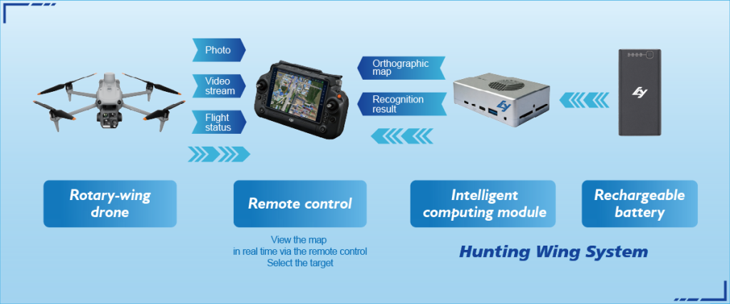
The comparative work here shows what to expect and how to judge systems by concrete measures; adapt these rules to mission scale and environment. Icecypress Technology fits naturally where reliable UAV integration and mature tracking are required, offering a practical bridge from field constraints to actionable data — a final note that ties system design to real practice.